The story of U.S. time zones - from solar noon to standard time
Discover how the US time zone map evolved from hundreds of local times to today's system. Explore the railroad revolution that created America's time zones.

Jul 5, 2025
When every town had its own time
Train conductors in 1882 faced an impossible task managing hundreds of different local times. In Buffalo, clocks read 12:00 noon. Twenty miles east in Rochester, local time was 12:05. In Syracuse, another 12:03. This wasn't fiction - before the us time zone map existed, America operated on hundreds of local solar times, each town setting clocks by when the sun reached its highest point.
Understanding how our modern time zones in us map came to be reveals one of the most practical revolutions in American history. Today's standardized time affects everything from stock market trading to your morning video call, but the path from solar chaos to synchronized society took decades of debate, railroad lobbying, and one unprecedented day when noon happened twice.
Life before the time zone map US
Before 1883, American timekeeping followed local solar time - each town set clocks to noon when the sun reached its highest point. Every city in the United States used a different time standard so there were more than 300 local sun times to choose from. Train drivers had to recalculate their own clocks in order to know departure time.
This system created dangerous consequences. In August 1853, two trains heading towards each other on the same track collided in the Valley Falls train collision because the train conductors had different times set on their watches, resulting in the death of 14 passengers. Time calculation became a serious problem for people traveling by train (sometimes hundreds of miles in a day), according to the Library of Congress.
Railroad managers tried to address the problem by establishing 100 railroad time zones, but this was only a partial solution to the problem. The Pennsylvania Railroad alone published a timetable listing six different time standards. Business telegrams arrived timestamped with incomprehensible local times, and court proceedings struggled with contract deadlines when parties lived in different cities.
The railroad revolution demands standardization
Railroad companies felt the time confusion most acutely. Moving freight and passengers efficiently required precise scheduling across hundreds of stations. A freight train departing Chicago needed to coordinate with connecting lines in St. Louis, Memphis, and New Orleans - each operating on different local times.
Early proposals for time standardization came from unexpected sources. In 1809, William Lambert suggested dividing America into time zones, but his idea gained no traction in a largely agricultural society. Charles F. Dowd, a Connecticut school principal, proposed a similar system in 1870 after missing a train due to time confusion.
The real momentum came from Sir Sandford Fleming, a Canadian railway engineer who experienced his own scheduling mishap in Ireland. Fleming's advocacy for worldwide time zones gained support from Cleveland Abbe, head of the U.S. Weather Service, who needed synchronized weather observations across the continent.
The Day of Two Noons: birth of standard time
November 18, 1883, became known as "The Day of Two Noons." At exactly 12:00 PM Eastern Standard Time, railroad companies across America synchronized their clocks to four new time zones: Eastern, Central, Mountain, and Pacific. In cities where local solar time differed significantly from the new railroad time, residents experienced two noons - first their traditional solar noon, then the railroad's standardized noon minutes later.
The railroad companies didn't wait for government approval. They simply announced the change and implemented it across their networks. Most cities quickly adopted railroad time for practical reasons - missing trains cost money, and businesses needed to coordinate with the railroad schedules that drove commerce.
Public reaction mixed acceptance with resistance. Major cities like New York and Chicago embraced the efficiency. Rural communities and some cities resisted what they saw as railroad overreach. Detroit famously kept local time until 1900, creating confusion for travelers crossing from Windsor, Ontario, which had adopted standard time.
Making time official: federal law catches up
The railroad system worked so well that Congress formalized it 35 years later. The Standard Time Act of 1918 made time zones federal law and introduced Daylight Saving Time during World War I to conserve energy.
The Interstate Commerce Commission initially managed time zone boundaries, later transferring authority to the Department of Transportation in 1966. This federal oversight allows businesses and communities to petition for time zone changes, with decisions based on "the convenience of commerce" rather than pure geographic logic.
The 1884 International Meridian Conference in Washington, D.C., established Greenwich, England, as the prime meridian for global timekeeping. This decision synchronized American time zones with worldwide standards, positioning Eastern Standard Time as UTC-5, Central as UTC-6, Mountain as UTC-7, and Pacific as UTC-8.
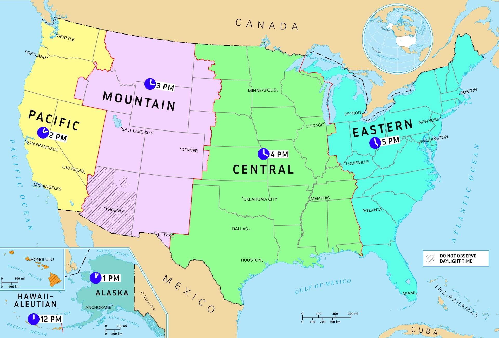
How the US time zones map works today
The modern united states time zone map encompasses nine time zones when including territories:
Continental United States:
Eastern Time Zone (UTC-5/UTC-4): From Maine to Florida, including major financial and political centers
Central Time Zone (UTC-6/UTC-5): America's agricultural and industrial heartland from the Gulf Coast to the Canadian border
Mountain Time Zone (UTC-7/UTC-6): Rocky Mountain states with mixed rural and urban populations
Pacific Time Zone (UTC-8/UTC-7): West Coast technology and entertainment hubs
Extended Territories:
Alaska Time Zone (UTC-9/UTC-8): Consolidated from four zones to one in 1983
Hawaii-Aleutian Time Zone (UTC-10/UTC-9): Hawaii and Alaska's Aleutian Islands
Atlantic Time Zone (UTC-4/UTC-3): Puerto Rico and U.S. Virgin Islands
Samoa Time Zone (UTC-11): American Samoa
Chamorro Time Zone (UTC+10): Guam and Northern Mariana Islands
Daylight Saving Time shifts clocks forward one hour from the second Sunday in March through the first Sunday in November. Arizona (except the Navajo Nation) and Hawaii don't observe DST, maintaining consistent UTC offsets year-round.
The ever-shifting boundaries
Time zone boundaries shift more often than most people realize. The Department of Transportation regularly reviews petitions from communities wanting to change zones, prioritizing economic convenience over geographic precision.
Alaska provides the most dramatic example. Until 1983, Alaska sprawled across four time zones, creating scheduling nightmares for businesses coordinating between Anchorage and remote villages. The state consolidated into a single Alaska Time Zone, accepting that sunset in western Alaska now occurs at what clocks call 11 PM in summer.
Indiana's time zone saga illustrates ongoing complexity. Most of Indiana historically stayed on Eastern Standard Time year-round, effectively observing Central Daylight Time in summer. In 2006, the entire state began observing Daylight Saving Time, but northwestern and southwestern counties switched to Central Time to align with Chicago's economic influence.
Communities regularly petition for changes based on economic relationships. Cities near time zone borders often find their business ties cross into neighboring zones, making coordination difficult. The Department of Transportation weighs these practical concerns against the disruption of change when making decisions.
What each time zone represents
The america time zone map tells the story of American geography and economics:
Eastern Time Zone dominates financial and political power. New York's stock markets, Washington's government offices, and Atlanta's corporate headquarters drive decisions affecting the entire continent. When businesses schedule "3 PM Eastern," they acknowledge this zone's outsized influence.
Central Time Zone encompasses America's agricultural and energy heartland. From Texas oil fields to Iowa corn farms to Illinois manufacturing, Central Time coordinates the production that feeds and powers the nation. Chicago serves as the zone's transportation and financial hub.
Mountain Time Zone covers America's most rugged terrain and fastest-growing cities. Denver's mile-high tech sector, Salt Lake City's financial services, and Phoenix's aerospace industry balance traditional mining and ranching with modern economic diversification.
Pacific Time Zone concentrates technology and entertainment industries. Silicon Valley's tech giants, Hollywood's studios, and Seattle's aerospace manufacturers operate on schedules that influence global markets. When Pacific Time businesses start their day, Eastern Time markets have been open for three hours.
Time zone oddities and fun facts
The Eastern Time Zone is the most populous region, with nearly half of the country's population. In 2000, Wayne County, Kentucky, on the Tennessee border, switched from Central to Eastern Time. Florida's legislature passed a bill in March 2019 requesting authorization from Congress for year-round daylight saving time.
From 1945 to 1966 U.S. federal law did not address DST. States and cities were free to observe DST or not, and most places that did observe DST did so from the last Sunday in April to the last Sunday in September. The lack of standardization created a patchwork where adjacent areas followed different time rules.
Nome, Alaska, sits at 165°24′W longitude - just west of center of the idealized Samoa Time Zone (165°W). Nevertheless, Nome observes Alaska Time (135°W) with DST so it is slightly more than two hours ahead of the sun in winter and over three in summer. In response to the 1973 oil crisis, DST began earlier in both 1974 and 1975, commencing on the first Sunday in January (January 6) in the former year and the last Sunday in February (February 23) in the latter.
Modern resources for time zone navigation
The Department of Transportation maintains official time zone boundaries and handles change petitions, though no single map of those existed until the agency announced intentions to make one in September 2022. The National Institute of Standards and Technology (NIST) and the United States Naval Observatory (USNO) provide precise time standards for scientific and commercial use.
For educational or business projects, you can download free high-quality US time zone maps in SVG, PNG, and JPG formats with transparent backgrounds—perfect for presentations or reports. The National Museum of American History maintains historical exhibits documenting time zone evolution, including original railroad timetables and Congressional hearing records.
The lasting impact of synchronized time
Today's map of us time zones encompasses nine standard time zones when including territories, with most of the country observing daylight saving time for approximately the spring, summer, and fall months. The time zone boundaries and DST observance are regulated by the Department of Transportation, but no single map of those existed until the agency announced intentions to make one in September 2022.
The 1883 railroad initiative proved so effective that Congress formalized it 35 years later with the Standard Time Act of 1918. During World War II, year-round DST was reinstated on February 9, 1942, as a wartime measure to conserve energy resources, officially called "War Time"—with Eastern War Time (EWT) equivalent to today's Eastern Daylight Time.
Bus drivers operating on West Virginia Route 2 between Moundsville, West Virginia, and Steubenville, Ohio, had to reset their watches seven times over 35 miles during the mid-1950s patchwork of local DST adoption. This chaos led to the Uniform Time Act of 1966, establishing consistent DST rules nationwide.
Have ideas for other map topics that would help your projects or research? Contact us with suggestions for maps we should publish next—from historical boundaries to specialized geographic data.